 Uyuni Salt Flats Trips
Salar de Uyuni: What It Is, Where It Is and What You Will See
The Salar de Uyuni is the largest salt flat on Earth, covering 10,582 square kilometers of southern Bolivia at about 3,663 m above sea level. This guide explains what the Salar de Uyuni actually is, how it formed, why it is so flat, what the lithium under the crust means, and what you see at each stop, from the Train Cemetery to Incahuasi Island. It also covers how visitors get onto the flat, which is only by 4x4. If you want to compare Uyuni tours by route and total by price and route, the homepage does that. For month-by-month weather, see the season guide.
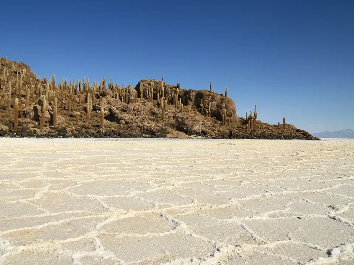
The dry-season salt crust and Incahuasi Island. Photo: Yoann Supertramp, CC BY 3.0, via Wikimedia Commons
Quick answer The salar in short
The Salar de Uyuni is the world's largest salt flat, 10,582 km² (4,086 sq mi) of blinding white crust at 3,663 m (12,018 ft) in Potosí Department, Bolivia. Its surface varies by less than one meter over the whole area, which makes it one of the flattest surfaces anywhere. You can only reach it by 4x4, on a tour from Uyuni town or in a hired jeep.
Key takeaways
- See the classic day loop, from the Train Cemetery through Colchani to Incahuasi Island, on the Uyuni salt flats highlights jeep tour.
- The mirror effect needs a thin sheet of water and comes with the rainy season. The month-by-month detail lives on the best time to visit Uyuni page.
- The salar after dark is a 4-hour evening trip, sunset then stars, on the sunset and stargazing tour.
- The salar is one stop on longer routes into the lagoons. Those continue in the Laguna Colorada guide.
What and Where the Salar de Uyuni Is
The salar sits on the Altiplano, the high plateau of the central Andes, in the Potosí Department of southwestern Bolivia.
Size and Elevation
The flat covers 10,582 km² (4,086 sq mi), making it the largest salt flat in the world. It runs an average of 126 km long and 84 km wide. Its elevation is usually given as 3,663 m (12,018 ft) above sea level, though sources disagree by a few meters: some travel operators cite 3,656 m, Wikipedia's Uyuni town page gives 3,700 m, and Uyuni airport sits at 3,665 m (12,024 ft). All these figures fall between 3,656 m and 3,700 m, which is high enough for altitude sickness to be a real consideration. At that height the air is thin, the sun is strong and the nights are cold. June to August nighttime lows around Uyuni town average between about -3.7°C and -4.0°C, and the higher ground on the multi-day routes runs colder still.
The nearest town is Uyuni, a former railway town of 29,672 residents counted in the 2012 census, in Antonio Quijarro Province. It sits on the edge of the flat and is the base for almost every jeep tour. Tour vehicles typically leave Uyuni around 10am, which is why morning flights from La Paz let travelers join a tour the same day.
How the Salar Formed
The salar is the floor of a chain of prehistoric lakes. Lake Minchin existed roughly 30,000 to 42,000 years ago. It transformed into the paleolake Tauca, dated to between 13,000 and 18,000 years ago by one method and 14,900 to 26,100 by another. The youngest of the prehistoric lakes, Coipasa, has been radiocarbon-dated to 11,500 to 13,400 years ago. As these lakes dried out they left behind dissolved salts in the lowest basin, and that trapped brine is the salar today.
The result is not a layer of dry table salt but a sandwich. The visible crust averages 8 meters thick. Beneath it sits a brine layer roughly 130 meters deep, saturated with dissolved minerals including lithium. Rain in the wet season floats a thin sheet of water over the crust, and that is what produces the mirror effect the region is famous for. No operator can promise the mirror, since it depends on recent rainfall and near-zero wind, but the mechanics come straight from the geology: flat crust, plus a little water, plus still air.
Why It Is So Flat
Over the entire 10,582 km² surface, the average elevation varies by less than one meter. That figure is the salar's defining feature. The basin was the deepest part of the dying lakes, and tens of thousands of years of flooding and evaporation deposited salt in perfectly level sheets. Every flood spread a new layer across the whole floor and every dry spell cemented it flat.
That flatness is also what makes the famous perspective photos work. With no landmarks and no horizon relief, distance is hard to judge, so a small object close to the lens and a person far behind it look the same size. The flatness also means there is nowhere to hide from wind or sun once you are out on the crust.
Sources: Salar de Uyuni on Wikipedia and UK travel advice for Bolivia.
The Salt Crust, the Hexagons and the Lithium Below
The surface you walk on and the liquid beneath it are two different resources, and both shape the region's economy.
The Crust and Its Hexagons
The salt crust averages 8 meters thick. In the dry season, from roughly April to November, it is hard enough to carry jeep traffic, and its surface breaks into the polygonal hexagon patterns that appear in almost every photograph of the region. The hexagons form as the salt dries and contracts after each flood, cracking into repeated cells of similar size. In the wet season, December to March, rain floats a shallow layer over the crust. A 2025 satellite-data study put the mirror window at late January through early March, with February the highest-probability month, and found the effect needs 2 to 20 cm of standing water and near-zero wind, most reliable in the mornings before roughly 9am. One wet-season field visit measured the reflective layer at just 1.8 centimeters.
Deep water changes the itinerary. When flooding is heavy the route to Incahuasi Island can close and tours adjust, which is a season question rather than a geography one, so it is covered on the best time to visit Uyuni page.
Lithium Under the Brine
The brine layer beneath the crust holds roughly 23 million tonnes of lithium, about 22% of the world's known lithium resources against a cited world total of 105 million tonnes. The concentration in the brine is about 0.3%. The lithium sits in the liquid brine layer about 130 meters deep, not in the crust you drive on. The extraction a day tour actually shows you is table salt.
The visible industry is at Colchani, where Bolivia's largest salt-processing cooperative operates. Roughly 25,000 tonnes of salt are excavated and processed there each year, out of an estimated 10 billion tonnes of salt in the flat. Workers scrape salt off the surface into pyramid-shaped piles, let it dry about 4 days, cart it to the village, cook it in ovens, add iodine, mill it and seal it into 1 kg sacks for sale in Bolivia and Brazil. No official cooperative or municipal page publishes the production figure, so it rests on travel-publisher sourcing.
Salar De Uyuni on Video
The salar in the wet season, from the jeep to the perspective photos, filmed by other visitors. Third-party video by Kara and Nate. We did not shoot it and have no relationship with the creator.
The Stops on the Salar
A day loop from Uyuni strings together a handful of stops before it reaches the open crust. The table compares each stop and what you do there, with figures from the sources compiled for this site.
The Train Cemetery and Colchani
The Train Cemetery sits about 3 km (1.9 miles) outside Uyuni town. Rail construction here started in 1888 and ended in 1892, and when the mining industry collapsed in the 1940s the locomotives were left where they stood. Rusted engines now stand in open ground a few minutes' drive from the town center, and most tours stop here first.
Colchani is the main entrance point to the salar and home to Bolivia's largest salt-processing cooperative. It is a village of just over 600 people. Sources disagree on its distance and direction from Uyuni: one cites 22 km north, another 20 km south, and a third simply 20 km, so treat any precise figure with caution. Tours stop at the salt works to watch the piling, drying and bagging, and the stop is part of the route on every Uyuni day loop in the catalog.
The Old Salt Hotel, the Dakar Monument and the Flags
The first salt hotel, Playa Blanca, was built in 1993 almost in the middle of the salar. It had 15 bedrooms, a dining room, a living room, a bar and a common bathroom, with no showers. In 2002 it was ordered dismantled as a lodge because the lack of sewage and waste infrastructure in the middle of the salt flat threatened the site's ecosystem. Its shell survives as a museum and rest stop. Inside you can still see salt sculptures, and outside stand the Dakar Rally monument and the Plaza de las Banderas, the flag monument.
A separate hotel, Palacio de Sal, was the first to open in the late 1990s, built between 1993 and 1995 by some accounts, and closed around 2002 for the same environmental reasons. It reopened around 2007 on the shore of the salar, 25 km from Uyuni, built with more than a million salt blocks over 4,500 m². The hotel's own site explains the move plainly: the new location lets it admire the flat without invading the natural formation or disrupting the people who live and work there. Overnight stays there are a hotel booking, not part of a standard day tour.
Incahuasi Island
Isla Incahuasi, sometimes called Fish Island or Cactus Island, rises to 3,656 m in the middle of the salt flat. It is covered in giant Trichocereus cacti reported to reach up to 12 meters tall and estimated at up to 1,200 years old. A loop trail to the summit viewpoint and back typically takes 30 to 45 minutes, with about 15 to 20 minutes of climbing on a marked rocky path. Good shoes matter more than fitness.
There is an entrance fee of around 30 Bs (about $3), paid in cash at a booth at the island's base, and it is not usually included in the tour price. The listings do not agree on the exact figure: one day tour quotes 35 Bs or $5, another 30 Bs or $5, so carry small cash for either. During heavy flooding in the rainy season the island sits in flooded ground and tours skip it. That is why some listings, such as the Uyuni salt flat day and sunset tour, state openly that the Incahuasi stop can be dropped from January to April. In the dry season the island is the classic photo stop of the day loop, with Tunupa volcano on the northern horizon.
Tunupa Volcano
Tunupa stands at 5,321 m (17,457 ft) on the northern side of the salar, in Potosí Department. It is an ultra-prominent peak, with 1,601 m (5,253 ft) of topographic prominence, located near the center of the Altiplano about 115 km east of the main volcanic arc. From the middle of the flat it is the one landform that breaks the horizon, and it shows in photographs taken from Incahuasi.
None of the one-day loops from Uyuni in the catalog names a Tunupa stop. They run the Train Cemetery, Colchani, the old salt hotel and Incahuasi in 8 to 10 hours, and see the 5,321 m summit from a distance. If a listing does name Tunupa, check what it drops to fit it in.
Stop-by-Stop at a Glance
This table pulls together the key figures for each stop on the salar loop, so you can see distances, fees and one key figure per stop in one place. Figures come from the sources compiled for this guide, and where sources conflict, both appear.
| Stop | Distance or Position | Fee | Key Figure | What You See |
|---|---|---|---|---|
| Train Cemetery | About 3 km (1.9 mi) outside Uyuni | None | Rail built 1888-1892 | Locomotives abandoned after the 1940s mining collapse |
| Colchani | About 20 km from Uyuni, direction disputed | None | About 25,000 tonnes of salt a year | Salt cooperative, drying piles, craft stalls |
| Playa Blanca old salt hotel | Middle of the salar | None stated | Built 1993, closed as a lodge 2002 | Salt sculptures, Dakar monument, Plaza de las Banderas |
| Incahuasi Island | Middle of the salar, 3,656 m | Around 30 Bs (about $3), cash | Summit loop 30-45 minutes | Cacti to 12 m, summit viewpoint, Tunupa views |
| Tunupa volcano | Northern edge of the salar, 5,321 m | None stated | 1,601 m of prominence | The flat's one horizon-breaking landform |
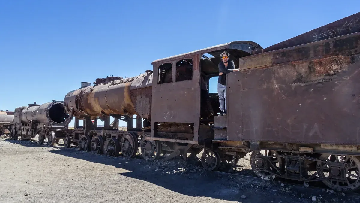
The Train Cemetery, about 3 km outside Uyuni. Photo: Cristobal Frigerio, CC BY-SA 4.0, via Wikimedia Commons
The Salar at Sunset and at Night
The flat changes completely in the last two hours of daylight, and after dark it becomes one of the darkest viewing platforms in South America.
Sunset
Uyuni sits on Bolivia Time, UTC-4, year-round, so only the sun's position shifts with the seasons. A commonly cited representative figure gives sunrise about 7:04 AM and sunset about 6:02 PM, with the latest sunrise around early July and the earliest sunset in early June at about 5:55 PM. A dated mid-September reading gives sunrise about 6:14 AM and sunset about 6:30 PM, so the two figures conflict by season and you should check the day you travel. Day tours that end with sunset keep the jeep on the crust for that last light before the drive back.
In the wet season the same sunset reflects off the water layer, which is what the mirror-effect evening tours are built around. The sunset mirror-effect day tour runs 9 hours for $80 and ends with sunset in the salt water region, with rain boots supplied for wading. One practical note from the listing itself: pickup from hotels on the edge of the salar, such as the Palacio de Sal or Luna Salada, costs $30 extra, so staying in Uyuni town keeps the tour cheaper.
The Salar at Night
After sunset there are no settlements on the flat itself, and the evening tour listings sell it as one of the clearest night skies on Earth. On a moonless night the Milky Way is visible with the naked eye, and in the wet season a shallow water layer can double it, with stars reflected underfoot. The dedicated evening tours run 4 to 5 hours: the Uyuni sunset and stargazing tour covers sunset plus stars in 4 hours for $60, leaving around 4:30 PM and back around 8:30 PM, with waterproof wellies and hot coffee included. A 5-hour group option runs 3:00 PM to 8:00 PM for $45.
Two honest caveats apply. First, stargazing conditions depend on season, rainfall and moon phase, and no operator guarantees either the stars or the mirror. A full moon washes out the Milky Way even when the sky is cloudless. Second, nights on the flat are cold in any season at 3,663 m, and June to August lows around Uyuni average about -3.7°C to -4.0°C. Warm layers, gloves and a hat are not optional, which the evening tour listings say themselves.
How Visitors Reach the Salar
There is no road across the salar for ordinary vehicles and no public transport onto the crust. Access is by 4x4 only.
Only by 4x4, With a Tour or a Hired Jeep
Every visitor reaches the salar in a four-wheel-drive vehicle, either on an organized tour or in a hired jeep with a driver. Tour jeeps from Uyuni carry up to 6 travelers each and enter through Colchani, which is the functional gate to the flat. Private options exist too: a full-day private tour costs $320 plus $5 in mandatory extras for the whole jeep of up to 4 travelers, so $325 per jeep, or about $81 each when four share it.
Day loops run about 8 to 10 hours and cover the salar only. If you want the colored lagoons, geysers and flamingos of the Eduardo Avaroa reserve, that is a 3-day route into the southwest, covered in depth on the Laguna Colorada guide. What the route covers decides the trip, and the multi-day routes also climb well above the salar, to passes between 4,200 m and 5,400 m, so altitude planning matters.
Getting to Uyuni Town First
Most visitors reach Uyuni town by overnight bus, by plane or by train. The overnight bus from La Paz covers about 569 km, with companies including Trans Omar (departs 21:00, arrives 06:00, advertised at about 9 hours), Todo Turismo (departs 9:00 PM, 10 hours, $49 for the Cama Ejecutivo class) and Panasur (departs 8:00pm daily). From Potosí the bus takes about 4 hours, from about $8-9 per ticket, with the distance given as 148 km by one source and 208 km by another. From Sucre it is about 8 hours, from $19, over 229 km or 377 km depending on the source.
Uyuni's Joya Andina International Airport (UYU) sits at 3,665 m just northwest of town, and Boliviana de Aviación is the sole scheduled carrier, flying to La Paz, Cochabamba and Cusco. The La Paz flight takes about 1 hour, which is why morning arrivals can join a same-day tour. By train, the Expreso del Sur runs Oruro to Uyuni on Tuesday and Friday, departing 14:30 and arriving 21:20, with Ejecutivo class at Bs 100 (about $9). If you are coming from Chile instead, see the San Pedro de Atacama to Uyuni crossing guide. What the whole trip costs once you are there, including the cash fees on top of the tour price, is laid out on the Uyuni tour price comparison page.
Which Way to See the Salar
The salar is one place, but there are several honest ways to see it. Match the option to your time and your route.
If You have one day in Uyuni
Take a full-day loop such as the 9-hour tour with sunset, which covers the Train Cemetery, Colchani, the crust and, outside the rainy season, Incahuasi Island. That is enough to see the flat itself.
If You care most about the night sky
Book a short evening run like the sunset and stargazing tour and accept that stars and mirror both depend on the moon and the weather. Check moon phase before you commit.
If You have three days and want the lagoons and geysers too
Take a multi-day route such as the 3-day salt flat and colored lagoons tour and read the altitude and accommodation notes first. The second night is a shared room at Laguna Colorada, 4,278 m up.
If You want the mirror effect
Go in the rainy season and plan for flexibility, since deep water can close the Incahuasi route. The month-by-month detail is on the best time to visit Uyuni page.
Salar de Uyuni: Common Questions
What is special about the Salar de Uyuni?
It is the largest salt flat on Earth at 10,582 km² (4,086 sq mi), and the flattest, varying by less than one meter across the whole surface. In the wet season a thin water layer turns about 129 km (80 miles) of it into what is described as the world's largest mirror. The routes that cover the flat and the lagoons together are laid out side by side in the Uyuni salt flats tour routes.
Where is the Salar de Uyuni and what country is it in?
It is in Bolivia, in the Potosí Department of the southwest, on the Altiplano at about 3,663 m (12,018 ft) above sea level. The gateway town is Uyuni, reached by overnight bus, by train from Oruro or by plane to Joya Andina airport. Buses, trains and flights into town are detailed on the La Paz to Uyuni guide.
Why are there hexagons on the salt flat?
The crust, which averages 8 meters thick, cracks into polygonal cells as it dries and contracts after each flood. In the dry season the pattern is bare and sharp. In the wet season water covers it and the mirror replaces the hexagons. What each month looks like is the subject of the season guide.
Can you visit Incahuasi Island year-round?
No. In heavy flooding during the rainy season the island sits in flooded ground and jeeps cannot reach it, so tours skip the stop. In the dry season the trail loop takes 30 to 45 minutes and carries a cash fee of around 30 Bs (about $3). Whether the stop runs on a given day is the operator's call, and listings for the highlights day tour state the fee is paid separately in cash.
Is the Salar de Uyuni safe at night?
Night visits run on organized jeeps only, and the cold is the everyday risk: June to August lows average about -3.7°C to -4.0°C at Uyuni. The circuit has a jeep safety record too, with two documented accidents in 2008, including a head-on collision. The UK FCDO also warns that protest road blockades appear without warning. Evening runs are compared on the Every Uyuni salt flats tour.
How do you get onto the salt flat itself?
Only by 4x4, either on a tour from Uyuni or in a hired jeep with a driver. Jeeps enter through Colchani and carry up to 6 travelers. Private jeeps are bookable as well, and one full-day private option runs the same loop as the shared tours, stopping at the old salt hotel, the Dakar monument and Incahuasi: see the private full-day tour.
What does the salt flat look like after dark?
In the dry season the crust is bare white under a full star field, and the Milky Way is visible to the naked eye on moonless nights. In the wet season a still water layer can mirror the stars underfoot. Both depend on moon phase and cloud, and no operator can promise them. Evening tours that target the sky run 4 to 5 hours, such as this 5-hour stargazing and sunset option.