 Uyuni Salt Flats Trips
Laguna Colorada: The Red Lagoon of the Eduardo Avaroa Reserve
Laguna Colorada is the shallow red lagoon at 4,278 m in the Eduardo Avaroa Andean Fauna National Reserve in Bolivia's southwest. It is the headline stop on the 3-day lagoons route out of Uyuni, and a one-day salt flat loop never reaches it. This guide covers what turns the water red, which flamingo species feed in it, the reserve entrance fee you pay in cash, the basic refuges beside the shore, and every other stop the route makes on the way, from the Árbol de Piedra to Sol de Mañana and Laguna Verde. It does not cover the salar itself, which has its own guide, or the border crossing into Chile. To see how these stops fit the wider market, compare every Salar de Uyuni tour before you book.
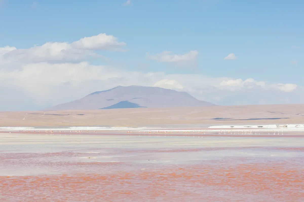
Andean flamingos at Laguna Colorada. Photo: Diego Delso, CC BY-SA 4.0, via Wikimedia Commons
Quick answer Laguna Colorada at a glance
Laguna Colorada sits at 4,278 m (14,035 ft) in the Eduardo Avaroa reserve in southwest Bolivia, and its water looks red because wind and sun act on pigmented algae living in the shallow water, which is less than 1 m deep. Three flamingo species feed there: James's, Andean and Chilean. You reach it only on a multi-day jeep route, and the reserve entrance fee of 150 Bs (about $13) per foreign visitor is paid in cash and usually is not part of the tour price.
Key takeaways
- See the red lagoon on the 3-day salt flat and lagoons tour, which lists at $290 with $62 of mandatory extras on top.
- Check why the water is red and how many flamingos gather in the flamingos section.
- Budget the cash fees with the reserve fee table.
- New to the region? Start with the Salar de Uyuni guide to see how the salt flat and the lagoons route differ.
What Laguna Colorada Is and Why the Water Is Red
Laguna Colorada is a shallow, wind-scoured lagoon inside the Eduardo Avaroa Andean Fauna National Reserve in Potosí Department, close to the Chilean border.
The Red Water, Explained
The lagoon sits at 4,278 m (14,035 ft) above sea level and is very shallow, less than 1 m (3 ft 3 in) deep. The red colour comes from the effect of wind and sun on pigmented micro-organisms, algae, that live in the water. The shade shifts through the day, because the light angle and the wind change how much pigment shows. Because the depth is under 1 m, the whole surface responds to the same wind and light, which is why photos of the lagoon range from pale pink to deep rust.
The site has formal protection on top of the reserve status. Laguna Colorada was designated a Ramsar Wetland of International Importance in 1990, and the protected area was expanded in 2009 from 513.18 km² to 14,277.17 km² to include surrounding high-Andean lakes and wetlands.
Where It Is and How High the Reserve Goes
The lagoon lies in the Eduardo Avaroa reserve, established in December 1973, which covers 714,745 hectares with altitudes between 4,200 m (13,800 ft) and 5,400 m (17,700 ft). That altitude band matters. Uyuni town, where most tours start, sits around 3,656 m to 3,700 m depending on the source.
The reserve's floor of 4,200 m is already 500 m or more above town, and the geysers at about 4,900 m sit roughly 1,200 m higher than your starting point. The jump is steep enough that altitude sickness is a real risk on this route, and it is covered in detail in the Uyuni altitude guide.
Key Figures
The table below compares Laguna Colorada with the other named lagoons and landmarks on the southwest route, using the elevations and physical figures published for the reserve and its main sites. Conflicting figures are shown as conflicts.
| Site | Elevation | Notable fact |
|---|---|---|
| Laguna Colorada | 4,278 m (14,035 ft) | Less than 1 m deep, red from pigmented algae |
| Laguna Verde | 4,310 m (14,140 ft) | Green-turquoise from arsenic and other mineral suspensions |
| Laguna Hedionda | About 4,532 m | Surface area roughly 3.2 km² |
| Sol de Mañana geysers | About 4,900 m (sources also cite 4,850 m and a sign reading about 4,905 m) | Among the highest geothermal fields in the world |
| Salvador Dalí Desert | About 4,750 m average | Covers roughly 110 km² |
| Árbol de Piedra | Siloli plateau cited at roughly 4,000 m to 4,575 m (a conflict) | Volcanic rock shaped by wind, about 6-7 m tall |
| Licancabur volcano | 5,868 m (19,252 ft) | Overlooks Laguna Verde |
Sources: Salar de Uyuni on Wikipedia and UK travel advice for Bolivia.
The Flamingos of Laguna Colorada
The lagoon is one of the most important flamingo sites in the high Andes, and the birds are the main reason visitors walk its shore.
Three Species, One Lagoon
Laguna Colorada hosts James's, Andean and Chilean flamingos. James's flamingos are the most abundant species at the lagoon, with Andean and Chilean flamingos present in smaller numbers. The lagoon matters well beyond Bolivia: nearly a third of the entire James's flamingo population breeds here, so the shore you walk is one of the species' main nesting grounds.
How Many Birds, and When
The population swings hard with the seasons. Published counts report peak austral-summer concentrations above 40,000 birds and austral-winter lows under 1,000. A record 41,050 James's flamingo adults was counted at the lagoon in 1987. Nearly a third of the entire James's flamingo population and about 65% of the global Andean flamingo population breed at Laguna Colorada.
The practical consequence for travelers is simple. Visit in the southern summer and the shore can be crowded with birds. Visit in the southern winter, June to August, and the count can fall below 1,000 birds, still worth the stop but not the spectacle of summer. Note that the winter is also when the reserve is coldest, with Uyuni town itself averaging night lows of about -3.7°C to -4.0°C in June to August and the higher passes colder still.
Laguna Colorada on Video
The flamingos of the high lagoons in the breeding season. Third-party video by NBC. We did not shoot it and have no relationship with the creator.
The Reserve Entrance Fee and Other Cash Costs
The Eduardo Avaroa reserve charges every foreign visitor at the gate, and the fee is almost never inside the tour price.
What You Pay and How
Foreign visitors pay 150 Bs (about $13) to enter the Eduardo Avaroa Andean Fauna National Reserve, while Bolivian nationals pay 30 Bs (about $3). The fee is cash only and is usually not included in tour packages, so carry bolivianos in small notes. There are no ATMs once the jeep leaves Uyuni. The same rule applies to other stops: the Isla Incahuasi entrance on the salar runs around 30 Bs (about $3) per person, although one day-tour listing quotes 35 Bs or $5 for the same island, and the Termas de Polques changing facilities cost around 5 Bs.
One caution on the exchange rate. Bolivia has run a dual system since late 2025, with the official central bank rate alongside a higher market rate, so what your dollars fetch in the street can differ from the official figures quoted here.
Cash Costs on the Southwest Route
The table lists every fee published for stops on or near this route, all payable in bolivianos at the site. None of them comes from an official government fee table, because no SERNAP fee schedule was found published online. The figures come from travel-publisher pages and tour listings, and where two sources disagree both are shown.
- Tours that cross into Chile add a transfer cost on top, for example an optional $25 onward bus to San Pedro de Atacama on the Tours Transandino 3-day listing.
- Sleeping bag rental is excluded on some 3-day tours, so ask before you pack.
| Fee | Amount | Notes |
|---|---|---|
| Eduardo Avaroa reserve entrance, foreign visitors | 150 Bs (about $13) | Cash only, usually not in the tour price |
| Eduardo Avaroa reserve entrance, nationals | 30 Bs (about $3) | Cash only |
| Isla Incahuasi entrance | 30 Bs (about $3) in most sources, 35 Bs or $5 on one listing | Paid at a booth at the island's base |
| Termas de Polques changing room | Around 5 Bs | No separate pool admission charge |
The Listed Tour Prices Behind the Route
Because the fee is extra, the headline price is not the trip's price. The 3-day Andes Salt Expeditions route lists at $290, but the booking platform adds $62 of mandatory extras for a real total of $352 per person, with national park entrance fees and sleeping bag rental excluded on top of that. The Tours Transandino 3-day route lists at $309.90, mandatory extras add $10 for a total of $319.90, and the 150 Bs reserve fee and 30 Bs Incahuasi fee are separate again.
The On Experiences 3-day tour ending in San Pedro de Atacama costs $450 with meals and the Chile transfer included but entrance fees excluded.
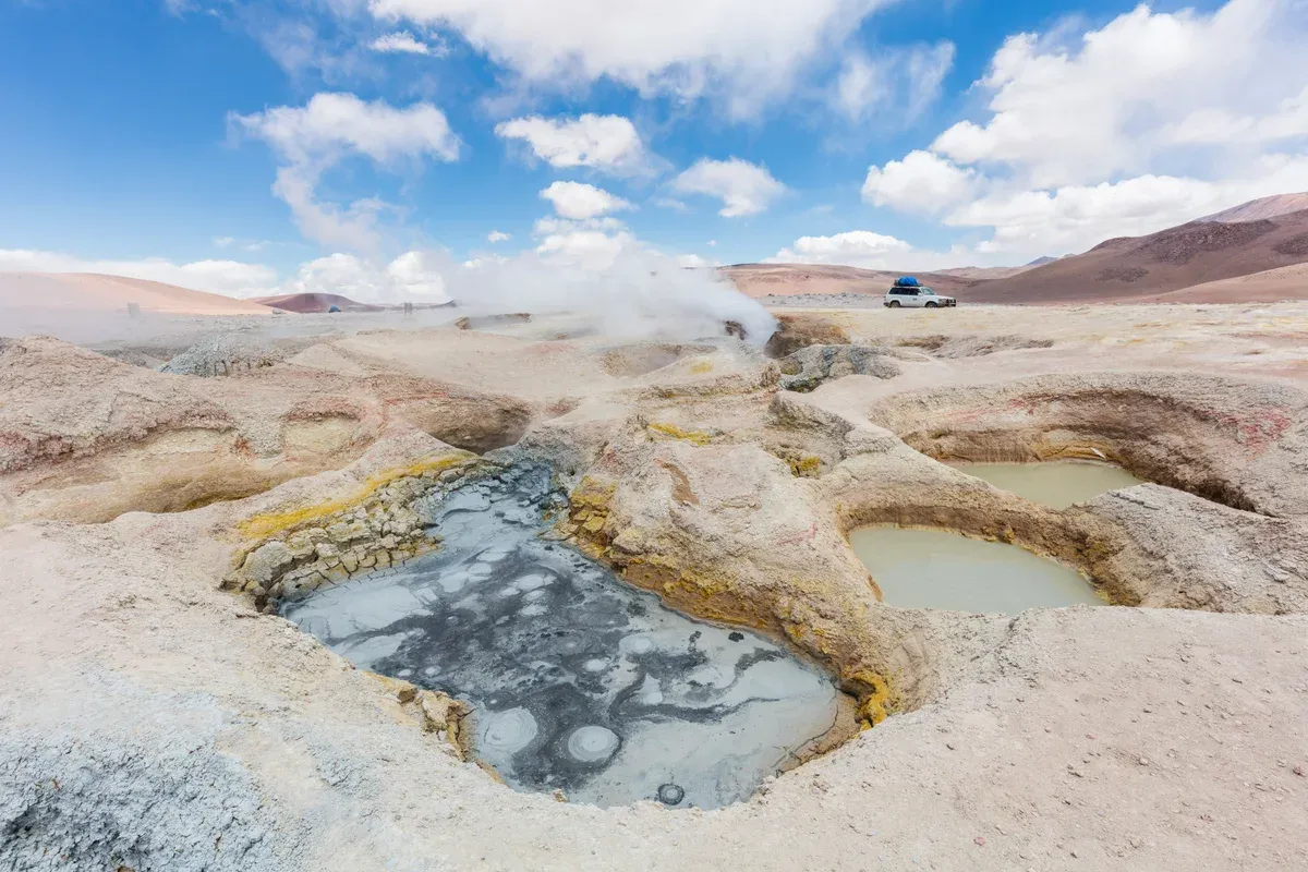
The mud pools of Sol de Mañana. Photo: Diego Delso, CC BY-SA 4.0, via Wikimedia Commons
Sleeping Beside Laguna Colorada
Most 3-day routes spend the second night in basic refuges at or near Laguna Colorada, and you should know exactly what that means before booking.
What the Refuges Are Actually Like
The accommodation is basic and the listings are honest about it. One 3-day tour puts night 2 in the Hostal Los Andes at Laguna Colorada, a shared room with a shared bathroom. Another puts it in the Laguna Colorada Refuge, a shared dormitory with 2 to 6 beds and a shared bathroom, described as basic with no heating, where hot showers work about 75% of the time and a sleeping bag is included from May to September for the cold winter nights. Internet access is very limited on day 2 of the route.
The reason for the spartan standard is the location. The lagoon sits at 4,278 m, inside a reserve where altitudes run up to 5,400 m, far from any town with infrastructure. Expect freezing nights, thin air and short hot water.
Who Should Skip the Night There
One 3-day listing advises passengers with altitude sickness risk, pregnancy or back problems against the route outright, and another is not suitable for children under 3, pregnant women or people with back problems. If you sleep badly at altitude, or you have never been above 4,000 m, read the Uyuni altitude sickness guide and acclimatise in Uyuni or La Paz first. The CDC advises moving your sleeping altitude by no more than about 500 m per night above 3,000 m, which this route does not do, so the risk is yours to manage.
Every Other Stop on the Southwest Lagoons Route
Laguna Colorada is the middle of a chain of stops. Here is what the 3-day route visits besides it, with altitudes.
Árbol de Piedra and the Siloli Desert
The Árbol de Piedra, or Stone Tree, is a volcanic rock formation in the Siloli Desert shaped by wind into a tree-like silhouette about 6-7 m tall. The Siloli plateau's elevation is a documented conflict in the sources, with figures from roughly 4,000 m up to about 4,500 m, and about 4,575 m at the viewpoint itself. The 3-day listings from Uyuni name it as a day 2 stop, reached before the jeep drops toward Laguna Colorada at 4,278 m.
The High Lagoons
Day 2 of most routes crosses a chain of altiplano lagoons including Cañapa, Hedionda and Chiar Khota, sitting between roughly 4,100 m and 4,700 m and ringed by volcanoes. Laguna Hedionda itself sits at about 4,532 m with a surface of roughly 3.2 km², and flamingos feed on several of them. No single authoritative elevation exists for Laguna Cañapa specifically, so listings that name one exact figure are guessing.
Sol de Mañana Geysers
The Sol de Mañana geyser field sits at about 4,900 m (16,100 ft) per Wikipedia, making it among the highest geothermal fields in the world. Two other figures circulate, 4,850 m from operator and guide sources and about 4,905 m from a sign at the site reported secondhand. The basin covers roughly 10 km², with spring temperatures reaching about 30°C and fumaroles about 70°C. At about 4,900 m it is the highest named stop on the route, roughly 600 m above the lagoon where you slept, so walk slowly between the vents.
Polques Hot Springs
The Termas de Polques thermal pool holds at about 29°C against ambient air that can drop to -5°C to -10°C, on the shore of the Salar de Chalviri inside the reserve. The springs come from volcanic activity linked to the nearby Polques volcano. The pool's elevation is commonly cited at about 4,400 m, with one source giving 4,394 m.
Changing facilities cost around 5 Bs and the pool itself has no separate admission charge. Bring a towel and dry layers, because you climb out into air that can be 34-39°C colder than the water.
Dalí Desert, Laguna Verde and Licancabur
The Salvador Dalí Desert sits at about 4,750 m average elevation and covers roughly 110 km² in Sur Lípez Province. Its name comes from wind-carved rock formations that resemble the painter's surrealist landscapes. The route then reaches Laguna Verde at 4,310 m, whose vivid green-turquoise colour comes from mineral suspensions including arsenic, shifting as sediment is disturbed.
The nearly perfect cone of Licancabur, an inactive volcano of 5,868 m (19,252 ft), stands over the lagoon. The Hito Cajón border pass at 4,480 m sits within the reserve near Laguna Verde, and tours ending in Chile hand over there. The crossing itself is covered in the San Pedro de Atacama to Uyuni guide.
The 3-Day Route to Laguna Colorada, Stop by Stop
Times and stop order vary by operator and season, so treat this as the shape of the route rather than a timetable. It reflects the stops named in the tour listings compared on this site.
-
Day 1, morning
Uyuni to the salar
Jeeps leave Uyuni in the morning, with a 10:30 AM start on the On Experiences listing, and run the stops on the salt flat itself: the Train Cemetery about 3 km from town, Colchani, and the salar, which has its own guide. Many routes add Isla Incahuasi at 3,656 m, where the cactus loop trail takes 30-45 minutes and the entrance is around 30 Bs (about $3). In the rainy season the island stop can be skipped when flooding closes access.
-
Day 1, night
First night on the edge of the salar
Listings put this night in salt hotels and hostels on the salar's edge, for example a private room with two separate beds or a queen bed at one salt hostel. This night sits close to the level of the salar, which Wikipedia puts at 3,663 m, so it is more than 600 m lower than the next one.
-
Day 2
The high lagoons and the Siloli Desert
The jeep climbs into the lagoon chain between 4,100 m and 4,700 m, stopping at Cañapa, Hedionda at about 4,532 m and neighbouring lagoons, then crosses to the Árbol de Piedra in the Siloli Desert. This is the day the altitude rises fastest.
-
Day 2, night
Laguna Colorada
The night goes to a basic refuge at or beside the lagoon at 4,278 m, a shared dormitory with 2 to 6 beds, no heating on some listings and hot showers working about 75% of the time on the On Experiences listing. The Andes Salt Expeditions listing carries an oxygen tank for this night.
-
Day 3, morning
Geysers and hot springs
Many routes open day 3 at the Sol de Mañana geysers at about 4,900 m, with fumaroles at about 70°C, then drop to the Polques hot springs, where the water holds at about 29°C. Days 2 and 3 run through the reserve, so keep the 150 Bs (about $13) fee in cash from the start.
-
Day 3, afternoon
Dalí Desert, Laguna Verde and the end point
The route passes the Dalí Desert at about 4,750 m and finishes at Laguna Verde at 4,310 m under the 5,868 m cone of Licancabur. Tours either turn back to Uyuni or continue a short distance to the Hito Cajón pass at 4,480 m for the transfer into Chile, which is not always included in the price.
Do and Don't at Laguna Colorada
The lagoon is inside a protected wetland at over 4,200 m, and small preparations change how the visit goes.
Do
- Do carry 150 Bs (about $13) per person in cash for the reserve gate, because the fee is cash only and there are no ATMs after Uyuni.
- Do spend 2-3 nights acclimatising first, since the CDC finds staging at around 2,450-2,750 m markedly protective, because the route climbs to refuges at 4,278 m and geysers near 4,900 m.
- Do bring a sleeping bag or rent one for the refuge night, since the second-night lodging on one listing has no heating and winter nights run well below freezing.
- Do plan the visit in the southern summer if flamingo numbers matter, because peak counts exceed 40,000 birds against winter lows under 1,000.
Don't
- Don't expect the listed tour price to be the final price, because the reserve fee, the Incahuasi fee, the sleeping bag and any Chile transfer are commonly excluded.
- Don't book a one-day salt flat loop and expect the red lagoon, because the lagoons and geysers need the 3-day route.
- Don't walk into the water or disturb the flamingos, because the lagoon is a Ramsar wetland of international importance and a major breeding site.
- Don't underestimate the altitude jump from Uyuni at around 3,656-3,700 m to the route's high points, and turn back if symptoms worsen.
Laguna Colorada FAQ
Why is Laguna Colorada red?
The red colour comes from the effect of wind and sun on pigmented micro-organisms, algae, living in the water. The lagoon is less than 1 m deep at 4,278 m, so sunlight and wind act on the pigments across the whole surface. The tours that see it are the 3-day lagoons routes such as the 3-day salt tour with Laguna Colorada.
Where is Laguna Colorada located?
It sits at 4,278 m (14,035 ft) in the Eduardo Avaroa Andean Fauna National Reserve in Potosí Department, southwest Bolivia, near the Chilean border. The reserve covers 714,745 hectares with altitudes from 4,200 m to 5,400 m. Most visitors reach it from Uyuni, which you can plan via the Salar de Uyuni tours side by side.
How can I reach Laguna Colorada in Bolivia?
Only by 4x4 on a multi-day route, usually the 3-day tour from Uyuni, or from San Pedro de Atacama in Chile on tours that cross the border. There is no public transport into the reserve. The 3-day tour ending in San Pedro de Atacama reaches the lagoon on night 2 and costs $450.
What flamingos live at Laguna Colorada?
Three species feed there: James's, Andean and Chilean flamingos, with James's the most abundant. A record 41,050 James's flamingo adults was counted at the lagoon in 1987, and about 65% of the global Andean flamingo population breeds there. See the routes on the comparison of Uyuni salt flats tours to find which include the lagoon.
How much is the Eduardo Avaroa reserve entrance fee?
Foreign visitors pay 150 Bs (about $13) and Bolivian nationals pay 30 Bs (about $3), cash only, and the fee is usually not included in tour packages. No official government fee table was found published online, so figures come from travel-publisher sources. The 3-day Andes Salt Expeditions route lists entrance fees among its exclusions.
How high is Laguna Colorada and will I get altitude sickness?
The lagoon sits at 4,278 m (14,035 ft), and the route's geyser field reaches about 4,900 m, well above Uyuni town at around 3,656-3,700 m. One 3-day listing advises travelers with altitude sickness risk, pregnancy or back problems against the route. Read the altitude guide and stage your ascent before you book a lagoons tour.
Can you swim in Laguna Colorada?
None of the tour listings compared here offers a swim in Laguna Colorada, which is under 1 m deep and a protected breeding site. The bathing stop on this route is the Termas de Polques hot springs, where the pool holds about 29°C against air that can fall to -10°C, with changing facilities for around 5 Bs. The springs are a named stop on the 4-day San Pedro de Atacama round trip.